[gtranslate]

OGC Web Coverage Service (WCS) Standard

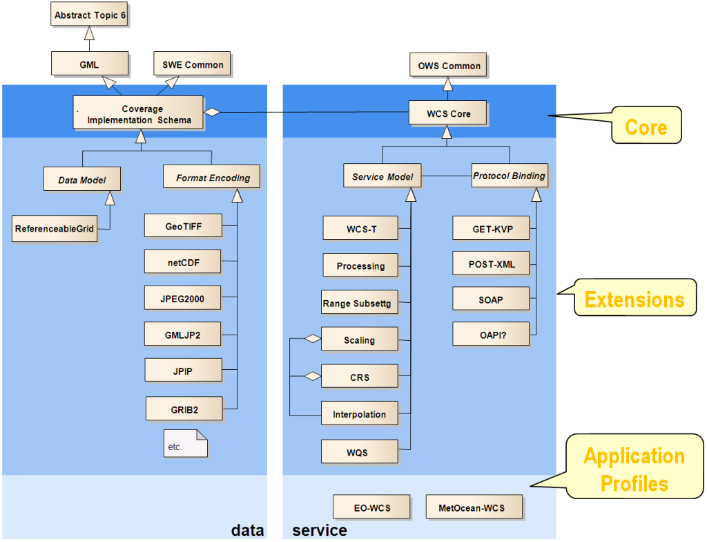
This standard offers multi-dimensional coverage data for access over the Internet. WCS Core specifies a core set of requirements that a WCS implementation must fulfill. The OGC Web Coverage Service (WCS) supports electronic retrieval of geospatial data as “coverages.” Coverages are digital geospatial information representing space/time-varying phenomena, specifically spatio-temporal regular and irregular grids, point clouds, and general meshes. Core requirements are mandatory for any implementation claiming to be conformant with WCS. Extensions to the core define extensions to meet additional requirements, such as the response encoding. Additional extensions are required in order to completely specify a WCS for implementation.

Web Coverage Service
OGC Open Call Requests
Overview

A Web Coverage Service (WCS) offers multi-dimensional coverage data for access over the Internet. WCS Core specifies a core set of requirements that a WCS implementation must fulfil.

2) Documents

WCS service model

Version Document Title (click to download) Document # Type
2.1 Core:
OGC® Web Coverage Service (WCS) Interface Standard – Core, version 2.1 17-089r1 IS
2.0 Core:
OGC® WCS 2.0 Interface Standard – Core, version 2.0.1 09-110r4 IS
Service Extensions:
OGC® Web Coverage Service Interface Standard – Transaction Extension 13-057r1 IS
OGC® WCS Interface Standard – Range Subsetting Extension, version 1.0.0 12-040 IS
OGC® WCS Interface Standard – Scaling Extension, version 1.0.0 12-039 IS
OGC® WCS Interface Standard – CRS Extension, version 1.0.0 11-053r1 IS
OGC® WCS Interface Standard – Interpolation Extension, version 1.1.0 24-018r1 IS
OGC® WCS Interface Standard – Interpolation Extension, version 1.0.0 12-049 IS
OGC® WCS Interface Standard – Processing Extension, version 2.0.0 08-059r4 IS
Protocol Extensions:
OGC® WCS Interface Standard – KVP Protocol Binding Extension, version 1.0.1 09-147r3 IS
OGC® WCS – XML/POST Protocol Binding Extension, version 1.0.0 09-148r1 IS
OGC® Web Coverage Service 2.0 Interface Standard – XML/SOAP Protocol Binding Extension, version 1.0.0 09-149r1 IS
Application Profiles:
OGC® MetOcean Application profile for WCS2.1: Part 0 MetOcean Metadata 15-045r7 IS
OGC® MetOcean Application profile for WCS2.1: Part 1 MetOcean GetCorridor Extension v1.0 15-108r3 IS
OGC® MetOcean Application profile for WCS2.1: Part 2 MetOcean GetPolygon Extension v1.0 17-086r3 IS
OGC® WCS Interface Standard – Earth Observation Application Profile, version 1.1 10-140r2 IS
OGC® WCS Interface Standard – Earth Observation Application Profile, version 1.0 10-140r1 IS

Coverage data model

Version Document Title (click to download) Document # Type
Core:
1.1.1 Coverage Implementation Schema with Corrigendum(“CIS”) 09-146r8 ISc
1.0.1 Coverage Implementation Schema (“CIS”), formerly named:
GML 3.2.1 Application Schema – Coverages (“GMLCOV”)
09-146r2 SAP
Format encoding extensions:
1.0 OGC® GML Application Schema – Coverages : GRIB2 Coverage Encoding Profile 16-060r2 IS
1.0.1 OGC® GML Application Schema – Coverages – GeoTIFF Coverage Encoding Profile 12-100r1 IS
1.0.0 OGC® GML Application Schema – Coverages JPEG2000 Coverage Encoding Extension 12-108 IS
2.0 CF-netCDF 3.0 encoding using GML Coverage Application Schema 14-100r2 IS
Data model extensions:
1.0.1 OGC Coverage Implementation Schema – ReferenceableGridCoverage Extension with Corrigendum 16-083r3 ISC
1.0 OGC Coverage Implementation Schema – ReferenceableGridCoverage Extension 16-083r2 IS

Deprecated OGC standards

Version Document Title (click to download) Document # Type
2.0
OGC® WCS 2.0 Interface Standard – Core, version 2.0.0 09-110r3 D-IS
OGC® WCS Interface Standard – KVP Protocol Binding Extension, version 1.0.0 09-147r1 IS
OGC® WCS Interface Standard – XML/POST Protocol Binding Extension, version 1.0.0 09-148r1 IS
OpenGIS Web Coverage Service (WCS) – Processing Extension, version 1.0.0 08-059r3 IS
WCS Processing Extension (WCPS) Abstract Test Suite (1.0.0) 08-053r2 TS
1.1
Web Coverage Service (WCS) Implementation Standard, version 1.1.2 07-067r5 D-IS
OpenGIS Web Coverage Service (WCS) Implementation Specification, version 1.1.1 07-067r2 D-IS
OpenGIS Web Coverage Service (WCS) Implementation Specification, version 1.1.0 06-083r8 D-IS
Web Coverage Service (WCS) 1.1 extension for CF-netCDF 3.0 encoding (0.2.2) 09-018 DP
OGC® WCS – Transaction operation extension, version 1.1.4 07-068r4 IS
1.0
OpenGIS Web Coverage Service (WCS) Implementation Specification, version 1.0.0 05-076 D-IS
OpenGIS Web Coverage Service (WCS) Implementation Specification, version 1.0 03-065r6 D-IS
0.7
Web Coverage Service 02-024 D-RP

Supportive documents (not standards)

Version Document Title (click to download) Document # Type
1.0 OGC® GML Application Schema – Coverages JPEG2000/JPIP Coverage Encoding Extension 14-110r2 BP
OGC WCS 2.0.1 Corrigendum Release Notes 12-052 Notes
Corrigendum 2 for the OGC Standard Web Coverage Service 1.1 (1.1.2) 07-066r5 Notes
Change Request: WCS: Add Transaction operation (1.1.0) 06-043r3 CR
Change Request: WCS: Proposal for WCS Transactional – WCS-T (1.0) 06-098 CR
OWS-5 WCS JPIP Coverage Subsetting Engineering Report, version 0.9.0 07-169 DP
WCS Change Request: Support for WSDL & SOAP, version 0.1.0 04-049r1 D-DP
OWS-8 WCS 2.0 Earth Observation Application Profile Engineering Report 11-096 PER
OWS-8 WCS 2.0 Earth Observation Application Profile Compliance Tests Engineering Report 11-095r1 PER

Open Calls and Requests

Members of the public can review draft standards and share feedback to ensure they are practical and widely applicable.

Explore Insights

You’ll find the latest thought leadership from OGC here.  

OverviewTestbed Europe is an emerging Open Geospatial Consortium (OGC) initiative exploring how Europe’s...